METAR and TAF for drone pilots: how to decode them
A METAR reports the weather at an airport now, and a TAF forecasts it. Each group below is decoded from the FAA Aviation Weather Handbook and tied to the Part 107 weather limits.
Practice with cited answers on your phone.
Get Part 107 TrainerKey facts
- METAR and TAF times end in Z, which means Coordinated Universal Time (UTC), not local time.FAA-H-8083-28B, 24.4.3.3 and 27.4.2.3
- Wind is coded as the direction it blows from, in tens of degrees relative to true north, followed by the speed in knots.FAA-H-8083-28B, 24.4.3.5
- Cloud heights are coded in hundreds of feet above ground level, so BKN025 is a broken layer at 2,500 feet AGL.FAA-H-8083-28B, 24.4.3.9
- The ceiling is the lowest broken or overcast layer, or the vertical visibility into an obscuration.AIM 7-1-28
- Part 107 requires at least 3 statute miles of flight visibility from the control station, and 500 feet below and 2,000 feet horizontally from clouds.14 CFR 107.51(c), (d)
- Most TAFs cover 24 hours and some major airports get 30-hour TAFs, for the area within 5 statute miles of the runway complex center.FAA-H-8083-28B, 27.4 and 27.4.1
A METAR is an observation of current surface weather at an airport, in a standard international format. A TAF is a forecast of the conditions expected within 5 statute miles of the center of an airport’s runway complex (FAA-G-8082-22, Chapter 3a; FAA-H-8083-28B, 27.4). The ACS lists both as knowledge areas for the remote pilot test (FAA-S-ACS-10B, UA.III.A.K2, UA.III.A.K3).
Many briefing services and weather apps show a plain-language version, but the FAA’s handbook says pilots should still know how to decode the raw report in case a source does not provide one (FAA-H-8083-28B, 24.4). Before every flight you must assess local weather conditions as part of your preflight check (14 CFR 107.49(a)(1)).
A worked METAR, group by group
The report below was constructed for this guide to show each group. It is not a report from any station.
METAR KOKC 141753Z AUTO 31012G22KT 280V340 4SM -SN BR FEW008 SCT015 BKN025 M01/M03 A3012 RMK AO2
| Group | Decoded |
|---|---|
| METAR | Routine report. SPECI is an unscheduled special report |
| KOKC | ICAO station identifier. In the conterminous U.S., K plus the three-letter identifier |
| 141753Z | 14th day of the month, 1753 UTC |
| AUTO | Fully automated, no human intervention. COR marks a corrected report |
| 31012G22KT | Wind from 310 degrees true at 12 knots, gusts to 22 knots |
| 280V340 | Direction varying from 280 to 340 degrees |
| 4SM | Visibility 4 statute miles |
| -SN BR | Light snow, mist |
| FEW008 SCT015 BKN025 | Few clouds at 800 feet, scattered at 1,500, broken at 2,500 feet AGL |
| M01/M03 | Temperature minus 1 degree Celsius, dewpoint minus 3 |
| A3012 | Altimeter setting 30.12 inches of mercury |
| RMK AO2 | Remarks: automated station with a precipitation discriminator |
Every row follows the format definitions in the handbook (FAA-H-8083-28B, 24.4.3). The ceiling in this report is 2,500 feet, not 800, because FEW and SCT layers are not ceilings.
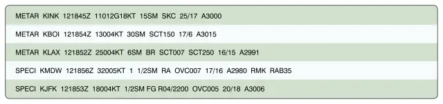
Wind, visibility and weather codes
Wind direction is the direction the wind comes from, coded in tens of degrees relative to true north and averaged over two minutes. Speed is in knots, with a leading zero below 10 knots (08KT). A G adds the gust, which means rapid fluctuations of 10 knots or more between peaks and lulls. VRB replaces the direction when the speed is 6 knots or less, a group such as 280V340 follows when the direction varies by 60 degrees or more at more than 6 knots, and 00000KT is calm (FAA-H-8083-28B, 24.4.3.5).
Visibility is in statute miles, with a space between a whole number and a fraction (1 1/2SM). At automated stations, M means less than, so M1/4SM is less than a quarter mile (FAA-H-8083-28B, 24.4.3.6).
Weather codes read in order: intensity, descriptor, then the phenomenon. A minus sign is light, no sign is moderate and a plus sign is heavy. VC means in the vicinity, 5 to 10 statute miles from the point of observation (FAA-H-8083-28B, 24.4.3.8). Common codes:
| Code | Meaning | Code | Meaning |
|---|---|---|---|
| RA | Rain | BR | Mist (visibility 5/8 SM or more) |
| SN | Snow | FG | Fog (visibility less than 5/8 SM) |
| DZ | Drizzle | HZ | Haze |
| TS | Thunderstorm | FU | Smoke |
| SH | Showers | GR | Hail |
Sources: AIM 7-1-28; FAA-H-8083-28B, Table 24-3.
Sky condition and the ceiling
Cloud cover is reported in eighths of the sky: FEW is 1/8 to 2/8, SCT is 3/8 to 4/8, BKN is 5/8 to 7/8 and OVC is 8/8. VV is vertical visibility into an obscured sky. The three digits after each contraction are the base height in hundreds of feet AGL (FAA-H-8083-28B, 24.4.3.9). CB (cumulonimbus) or TCU (towering cumulus) can be appended to a layer.
Two clear-sky codes trip people up. CLR comes from automated stations and means no layers were detected at or below 12,000 feet. SKC comes from a human observer and means no layers are present (FAA-H-8083-28B, Table 24-4).
The ceiling is the lowest layer reported as broken or overcast, or the vertical visibility into an obscuration, and ceiling heights are always above ground level (AIM 7-1-14; AIM 7-1-28).
Temperature, dewpoint, altimeter and remarks
Temperature and dewpoint are in whole degrees Celsius, with M for values below zero, so 04/M02 is 4 and minus 2 (FAA-H-8083-28B, 24.4.3.10). Watch the spread. When air reaches saturation with temperature and dewpoint close together, fog, low clouds and precipitation are highly likely, and frost on a small UA must be removed before flight (FAA-G-8082-22, Chapter 3b).
The altimeter group starts with A and gives inches of mercury without the decimal point, so A2992 is 29.92 (FAA-H-8083-28B, 24.4.3.11). RMK starts the remarks. AO1 marks an automated station without a precipitation discriminator and AO2 one with it (FAA-H-8083-28B, 24.4.3.13.3).
Temperature and pressure also drive density altitude, which affects how your aircraft performs. The weight and performance guide covers that side.
Reading a TAF
This TAF was also constructed for this guide:
TAF KOKC 141720Z 1418/1518 32012G22KT 5SM -SN BR BKN020
     TEMPO 1418/1420 2SM SN OVC012
     FM150300 34008KT P6SM SCT030
The TAF was issued on the 14th at 1720 UTC and is valid from the 14th at 1800 UTC to the 15th at 1800 UTC. Scheduled TAFs are issued four times a day, at 0000, 0600, 1200 and 1800 UTC (FAA-H-8083-28B, 27.4.2.3, 27.4.2.4). The first line uses METAR codes: wind 320 degrees true at 12 knots gusting 22, visibility 5 statute miles in light snow and mist, ceiling broken at 2,000 feet AGL. In a TAF, P6SM means more than 6 statute miles, SKC replaces CLR, and CB is the only cloud type forecast (FAA-H-8083-28B, 27.4.2.6, 27.4.2.9).
| Change group | What it means |
|---|---|
| FM150300 | From the 15th at 0300 UTC, a complete new forecast replaces everything before it |
| TEMPO 1418/1420 | Temporary changes with more than 50 percent probability, each lasting one hour or less and in total less than half the period. Elements not listed stay the same |
| PROB30 | A 30 percent chance of a thunderstorm or precipitation event. It is the only PROB group used in NWS TAFs |
| BECMG | A change expected during the stated period. NWS TAFs exclude BECMG |
| TAF AMD | An amended forecast that supersedes the previous one |
Sources: FAA-H-8083-28B, 27.4.2.1, 27.4.2.4, 27.4.2.10; AIM 7-1-28.
Read the date digits carefully. The AIM cautions that FM 10 0000 means 0000 UTC on the 10th, not 1000 UTC (AIM 7-1-28).
Applying the report to Part 107 limits
Part 107 requires flight visibility of at least 3 statute miles as observed from the control station, and it defines flight visibility as the average slant distance at which prominent objects can be seen and identified (14 CFR 107.51(c)). A METAR reports surface visibility at the station: at manual stations, the prevailing visibility seen throughout at least half the horizon circle, and at automated stations, a sensor-derived value (FAA-H-8083-28B, 24.4.3.6). Use the report to plan, then judge the visibility from where you stand.
You must also stay at least 500 feet below and 2,000 feet horizontally from clouds (14 CFR 107.51(d)). The rule is written in terms of clouds, not the ceiling, so the FEW008 layer in the example counts. If a cloud base at 800 feet AGL were over your area, staying 500 feet below it would hold you at or below 300 feet AGL.
The testing supplement includes a METAR figure (Figure 12) and a TAF figure (Figure 15) (FAA-CT-8080-2H). For the full set of operating limits, see the Part 107 rules guide, and for cited sample questions, the practice questions page.
Sources
Every fact on this page comes from these public FAA documents and the eCFR. If the FAA updates one, the source wins.
- Aviation Weather Handbook, FAA-H-8083-28B (2026)
- Aeronautical Information Manual, Chapter 7, Section 1: Meteorology
- Remote Pilot Small UAS Study Guide, FAA-G-8082-22
- 14 CFR 107.51, Operating limitations for small unmanned aircraft (eCFR)
- 14 CFR 107.49, Preflight familiarization, inspection, and actions for aircraft operation (eCFR)
- Remote Pilot Small UAS Airman Certification Standards, FAA-S-ACS-10B
- Airman Knowledge Testing Supplement for Sport Pilot, Recreational Pilot, Remote Pilot, and Private Pilot, FAA-CT-8080-2H