How to read a sectional chart for the Part 107 knowledge test
A sectional packs airports, airspace, terrain and obstacles into one 1:500,000 map. This guide decodes each symbol, checked against the FAA Chart Users’ Guide.
Practice with cited answers on your phone.
Get Part 107 TrainerKey facts
- Sectional charts use a scale of 1:500,000, where 1 inch equals 6.86 nautical miles, or about 8 statute miles.FAA-G-8082-22, Chapter 11
- Sectional and Terminal Area Charts are updated every 56 days, so check the effective date before you rely on one.FAA Chart Users' Guide, p. 23
- Airports with control towers and their data are shown in blue; all other airports and their data are shown in magenta.FAA Chart Users' Guide, p. 15
- Class D airspace is drawn with a blue dashed line, and Class E airspace that starts at the surface with a magenta dashed line.FAA Chart Users' Guide, pp. 16-17
- A Maximum Elevation Figure is rounded up to the nearest 100 feet and printed without its last two digits, so 28 means 2,800 feet MSL.FAA Chart Users' Guide, p. 12
- Beginning October 26, 2026, the FAA says the UAG test includes image-based questions not found in the testing supplement, using images from the latest sectional charts.Airman Testing Community Advisory, September 2026 Special Edition
A sectional chart is the FAA’s Visual Flight Rules chart for pilots who navigate by sight. It shows airports, airspace, terrain and obstacles at a scale of 1:500,000 (FAA Chart Users' Guide, p. 10). For Part 107, reading one means answering three questions about a spot on the map: what airspace is there, what the nearby airport’s data block says, and how high the ground and obstacles rise.
The chart legend explains most symbols, and the FAA Chart Users’ Guide is the full reference. The Remote Pilot Study Guide tells remote pilots to know the Chart Users’ Guide’s VFR Terms tab and its symbol sections on Airports, Airspace Information, Relief and more (FAA-G-8082-22, Chapter 2).
Scale, edition dates and coordinates
At 1:500,000, 1 inch on the chart equals 6.86 nautical miles, or about 8 statute miles (FAA-G-8082-22, Chapter 11). Unless a value is marked otherwise, miles in the Chart Users’ Guide are nautical miles and altitudes are feet above mean sea level (MSL) (FAA Chart Users' Guide, Introduction).
Sectionals and Terminal Area Charts are updated every 56 days (FAA Chart Users' Guide, p. 23). The 2016 study guide still says sectionals are revised semiannually, so go by the current Chart Users’ Guide and the dates printed on the chart. The FAA tells pilots to check effective dates and discard obsolete charts (FAA Chart Users' Guide, Introduction).
Parallels of latitude run east and west and measure degrees north or south of the equator. Meridians of longitude run pole to pole and measure degrees east or west of the Prime Meridian at Greenwich, England, up to 180 degrees. The 48 conterminous states lie between 25 and 49 degrees north and 67 and 125 degrees west (FAA-G-8082-22, Chapter 11). Ticked lines divide a sectional every 30 minutes of latitude and longitude into quadrants (FAA Chart Users' Guide, p. 12).
Airport symbols and the data block
Color is the first clue. Airports with control towers and their data are blue; all other airports and their data are magenta (FAA Chart Users' Guide, p. 15). The data block beside each airport reads like this, using the Chart Users’ Guide sample:
| Sample entry | Meaning |
|---|---|
| NAME (NAM) (PNAM) | Airport name, location identifier, ICAO identifier |
| CT - 118.3 | Control tower primary frequency |
| Small star after the tower frequency | Part-time tower; hours are in the tower frequencies tabulation |
| C in a circle | Follows the Common Traffic Advisory Frequency (CTAF) |
| ATIS 123.8 | Automatic Terminal Information Service frequency |
| 285 | Airport elevation in feet |
| L | Runway edge lighting from sunset to sunrise (*L means limitations, see the Chart Supplement) |
| 72 | Longest runway in hundreds of feet (7,200 feet); usable length may be less |
| 122.95 | Aeronautical advisory station (UNICOM) |
| RP 23, 34 | Right traffic patterns for those runways |
Airport elevation is the highest point on the usable portion of the landing areas. Runway length is rounded to the nearest 100 feet using 70 as the rounding point, so 8,070 feet is charted as 81 and 8,069 feet as 80. A dash replaces any item that is not available (FAA Chart Users' Guide, p. 15).
Do not mix up the two stars. A small star after the tower frequency means the tower is part-time. A star symbol on the airport itself means a rotating or flashing airport beacon that operates from dusk to dawn (FAA Chart Users' Guide, p. 15).
The CTAF is the frequency for airport advisory practices at an airport without an operating control tower. It may be a UNICOM, MULTICOM, FSS or tower frequency (FAA-G-8082-22, Chapter 11). When a part-time tower is closed, Class E surface area rules, or Class E rules to 700 feet above ground level (AGL) with Class G rules to the surface, apply (AIM 3-2-5). The ACS lists CTAF use and aeronautical charts as knowledge areas (FAA-S-ACS-10B, UA.V.A.K2, UA.V.B.K6a).
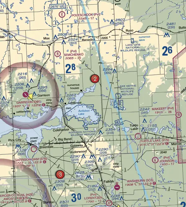
Airspace boundaries and altitude labels
| Airspace | How it is drawn | Altitude labels |
|---|---|---|
| Class B | Solid blue line | Ceiling over floor in blue, hundreds of feet MSL: 90 over 20 means 9,000 down to 2,000 feet MSL |
| Class C | Solid magenta line | Same format in magenta; T means up to but not including the overlying Class B floor, SFC means surface |
| Class D | Blue dashed line | Ceiling in a dashed box, hundreds of feet MSL; a minus means up to but not including that altitude |
| Class E surface area | Magenta dashed line | Starts at the surface |
| Class E from 700 feet AGL | Magenta vignette (shaded band) | Floor 700 feet AGL |
| Class E from 1,200 feet AGL next to Class G | Blue vignette | Floor 1,200 feet AGL |
Sources: FAA Chart Users' Guide, pp. 16-17, 26-27 and AIM 3-2-6. Where nothing else is shown, Class E begins at 1,200 feet AGL. Class A, from 18,000 feet MSL up to FL600, is not depicted on visual charts (FAA Chart Users' Guide, pp. 16-17).
These lines decide whether you need permission. You need prior authorization from Air Traffic Control to fly in Class B, C or D airspace, or within the lateral boundaries of the surface area of Class E airspace designated for an airport (14 CFR 107.41). So the magenta dashed line matters as much as the blue lines, while the shaded vignettes mark Class E floors above the surface. The drone airspace guide covers authorizations.
Special use and other airspace
Prohibited, restricted and warning areas are labeled P, R or W followed by a number. Alert areas use A and a number. MOAs are named, not numbered (FAA-G-8082-22, Chapter 2). The chart presents prohibited, restricted and warning areas in blue and alert areas and MOAs in magenta, with a tabulation giving altitudes, times of use and the controlling agency (FAA Chart Users' Guide, p. 20). Controlled firing areas are not charted (FAA Chart Users' Guide, p. 17).
Military Training Routes are labeled IR or VR. Four-digit numbers mean no segment above 1,500 feet AGL; three or fewer digits mean at least one segment above 1,500 feet AGL. Only temporary flight restrictions relating to national security are charted (FAA Chart Users' Guide, p. 18), so a clean chart does not mean there is no TFR. Check NOTAMs.
Terrain, obstacles and Maximum Elevation Figures
Contour lines join points of equal elevation. Basic contours are 500 feet apart, intermediate contours are typically 250 feet, and close spacing means steep slopes (FAA Chart Users' Guide, p. 10). Color tints run from light green for lower elevations to dark brown for higher ones (FAA Chart Users' Guide, p. 11).
Sectionals typically show man-made obstacles taller than 200 feet AGL, or taller than 299 feet AGL inside yellow city tint. The elevation of the top in MSL is printed with the AGL height in parentheses below it (FAA Chart Users' Guide, p. 11). In the legend example, 2049 over (1149) is a structure whose top is 2,049 feet MSL and which stands 1,149 feet tall (FAA-CT-8080-2H, Legend 1). Separate symbols mark obstacles below 1,000 feet AGL and 1,000 feet AGL and higher (FAA Chart Users' Guide, p. 33). UC means under construction or not yet verified, a group symbol shows only the highest obstacle in congested areas, and guy wires may extend outward from obstacles (FAA Chart Users' Guide, p. 11).
The Maximum Elevation Figure (MEF) is the highest elevation within a quadrant, including terrain and obstacles such as towers and trees. It is rounded up to the nearest 100 feet, and the last two digits are not shown (FAA Chart Users' Guide, p. 12). A large 2 beside a smaller 8 is 2,800 feet MSL. In the guide’s example, an obstacle top of 2,649 feet MSL plus 100 feet of possible error is 2,749, raised to 2,800. When natural terrain is the highest feature, a 200-foot allowance for uncharted obstacles is added, and MEFs are not verified by field surveys (FAA Chart Users' Guide, p. 13).
The common trap is MSL versus AGL. MEFs and obstacle tops are MSL, while the Part 107 altitude limit is 400 feet above ground level, with an exception within a 400-foot radius of a structure (14 CFR 107.51(b)). See the Part 107 rules guide.
The testing supplement and the October 26, 2026 change
The UAG test uses testing supplement FAA-CT-8080-2H, which includes Legend 1, the sectional chart legend, and sectional chart excerpts. Each excerpt notes that it is not to scale and should not be used for navigation (FAA-CT-8080-2H).
The FAA’s September 2026 advisory says that beginning October 26, 2026, the Unmanned Aircraft General, Small (UAG) test will include image-based questions not found in the testing supplements, using up-to-date images from the latest sectional charts. The FAA says images in active test questions cannot be previewed, that candidates keep access to the testing supplement until it is removed, and that no removal date has been set (Airman Testing Community Advisory, September 2026 Special Edition).
So practice on current charts, not only the supplement excerpts. The FAA posts digital sectionals on its VFR charts page. For the test format, see the Part 107 test guide, and for cited sample questions, the practice questions page.
Sources
Every fact on this page comes from these public FAA documents and the eCFR. If the FAA updates one, the source wins.
- FAA Aeronautical Chart Users' Guide (landing page, effective 9 July 2026)
- FAA Chart Users' Guide, complete PDF (July 9, 2026)
- Remote Pilot Small UAS Study Guide, FAA-G-8082-22
- Aeronautical Information Manual, Chapter 3, Section 2: Controlled Airspace
- 14 CFR 107.41, Operation in certain airspace (eCFR)
- 14 CFR 107.51, Operating limitations for small unmanned aircraft (eCFR)
- Remote Pilot Small UAS Airman Certification Standards, FAA-S-ACS-10B
- Airman Knowledge Testing Supplement for Sport Pilot, Recreational Pilot, Remote Pilot, and Private Pilot, FAA-CT-8080-2H
- Airman Testing Community Advisory, September 2026 Special Edition
- FAA VFR Raster Charts (digital sectionals)