Drone airspace: classes, charts, LAANC and ATC authorizations
Where 14 CFR 107.41 requires ATC authorization, how each airspace class looks on a sectional chart, and how to get an authorization through LAANC or FAADroneZone.
Practice with cited answers on your phone.
Get Part 107 TrainerKey facts
- You need prior ATC authorization to fly in Class B, C or D airspace, or within the lateral boundaries of the surface area of Class E airspace designated for an airport.14 CFR 107.41
- A remote pilot does not need ATC authorization to operate in Class G airspace, and in most cases not in other Class E airspace.FAA-G-8082-22, Chapter 2
- LAANC provides near-real time airspace authorizations at pre-approved altitudes on the UAS Facility Maps.FAA, Part 107 Airspace Authorizations
- UAS Facility Maps are for information only and do not authorize flight at the altitudes they show.FAA, UAS Facility Maps
- You may not fly in prohibited or restricted areas without permission from the using or controlling agency.14 CFR 107.45
- You must comply with flight restrictions designated by NOTAM under 14 CFR 91.137 through 91.145 and 99.7.14 CFR 107.47
Under Part 107 you need prior authorization from air traffic control (ATC) to fly in Class B, Class C or Class D airspace, or within the lateral boundaries of the surface area of Class E airspace designated for an airport (14 CFR 107.41). Class G needs no ATC authorization, and in most cases neither does the rest of Class E (FAA-G-8082-22, Chapter 2). You request authorization through LAANC, in near-real time at or below UAS Facility Map altitudes, or through FAADroneZone (FAA, Part 107 Airspace Authorizations).
Operating limits such as the 400-foot ceiling are in the Part 107 rules guide.
What 107.41 and 107.43 require
In uncontrolled airspace, no notification or authorization is necessary to fly at or near an airport (AC 107-2A, 5.10.1).
Wherever you fly, you may not interfere with operations and traffic patterns at any airport, heliport or seaplane base (14 CFR 107.43). Avoid traffic patterns, approach corridors, taxiways, runways and helipads (AC 107-2A, 5.10.1). A drone hovering 200 feet above a runway that makes an aircraft delay its takeoff has interfered, even without breaking the right-of-way rule (AC 107-2A, 5.10.1.1).
Airspace classes at a glance
| Class | Typical shape | On the sectional | ATC authorization |
|---|---|---|---|
| B | Generally surface to 10,000 feet MSL around the busiest airports, a surface area plus two or more layers | Sector ceilings and floors in solid blue figures | Required |
| C | Generally surface to 4,000 feet above the airport elevation, usually a 5 NM radius core and a 10 NM radius shelf from no lower than 1,200 feet above the airport | Ceilings and floors in solid magenta figures | Required |
| D | Generally surface to 2,500 feet above the airport elevation, around airports with an operational control tower | Blue dashed line | Required |
| E surface area | Surface to a designated altitude or to the overlying controlled airspace | Magenta dashed line | Required |
| E above the surface | Base of 1,200 feet AGL in most areas, 700 feet AGL in many others | Magenta vignette (700 feet) or blue vignette (1,200 feet) | Not needed in most cases |
| G | Surface up to the base of the overlying Class E | Below the Class E floor | Not needed |
Shapes come from AIM 3-2-3 to AIM 3-2-6 and FAA-G-8082-22, Chapter 2; symbols from the FAA Chart Users' Guide, Airspace; authorization from 14 CFR 107.41 and FAA-G-8082-22, Chapter 2.
The AIM says each Class B, C and D area is individually tailored, so read the boundary from the chart (
AIM 3-2-3,AIM 3-2-4,AIM 3-2-5).
Reading floors, ceilings and part-time airspace
Class B and Class C altitudes are printed in hundreds of feet MSL with the last two zeros omitted, so a 40 means 4,000 feet MSL. A Class B floor preceded by a plus sign means “upward from above” that altitude, and operations at and below it are outside Class B. A Class C ceiling of “T” means up to, but not including, the floor of the overlying Class B. A minus sign in front of a Class D ceiling means from the surface to, but not including, that altitude (FAA Chart Users' Guide, Airspace).
Because these figures are MSL, subtract the ground elevation where you fly to find how far above you a floor sits (AC 107-2A, 5.12.2). More on chart symbols in the sectional chart guide.
Some Class D surface areas are part-time. When the tower closes, the airspace may revert to a Class E surface area or to Class G, and the Chart Supplement entry says “other times CLASS E” or “other times CLASS G” (AIM 3-2-5). A Class E surface area still requires authorization (14 CFR 107.41); Class G does not (FAA-G-8082-22, Chapter 2).
Class E and Class G
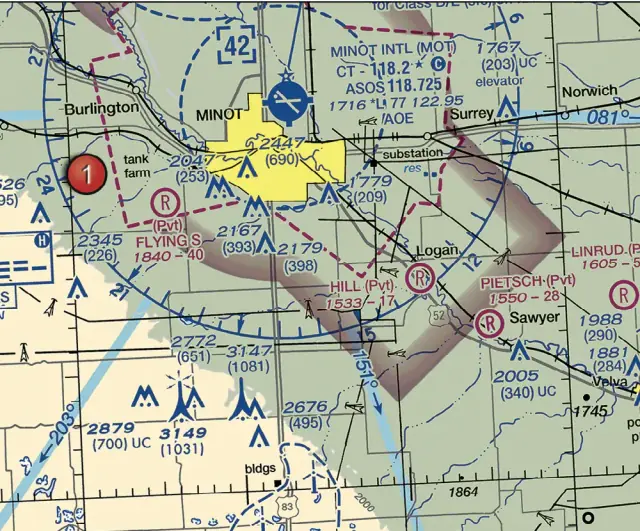
Class E is the controlled airspace not classified as Class A, B, C or D (FAA-G-8082-22, Chapter 2). Transition areas begin at 700 feet AGL (magenta vignette) or 1,200 feet AGL (blue vignette), stay in effect regardless of airport hours, and should not be confused with surface areas (AIM 3-2-6). Federal airways are Class E from 1,200 feet AGL up to, but not including, 18,000 feet MSL unless otherwise specified (AIM 3-2-6).
Class G is the airspace not designated as Class A, B, C, D or E (AIM 3-3-1). It runs from the surface to the base of the overlying Class E, and a remote pilot needs no ATC authorization there (FAA-G-8082-22, Chapter 2). So where the only controlled airspace overhead starts at 700 or 1,200 feet AGL, a flight at or below 400 feet needs no ATC authorization under 107.41. The airport rule in 107.43, special use airspace and any TFR still apply.
Special use airspace
Special use airspace is shown on charts, except controlled firing areas, temporary MOAs and temporary restricted areas (AIM 3-4-1).
- Prohibited areas (P plus a number) are airspace where flight is prohibited, for security or other reasons of national welfare (
AIM 3-4-2,FAA-G-8082-22, Chapter 2). - Restricted areas (R plus a number) contain unusual, often invisible hazards such as artillery firing, aerial gunnery or guided missiles (
AIM 3-4-3,FAA-G-8082-22, Chapter 2). You need permission from the using or controlling agency to fly in either kind (14 CFR 107.45). - Warning areas (W plus a number) extend from 3 NM outward from the coast and contain activity that may be hazardous to nonparticipating aircraft (
AIM 3-4-4,FAA-G-8082-22, Chapter 2). - Military operations areas carry names, not numbers (
FAA-G-8082-22, Chapter 2). They separate military training from IFR traffic, their status may change often, and VFR pilots should use extreme caution when they are active (AIM 3-4-5). - Alert areas (A plus a number) may hold a high volume of pilot training or unusual aerial activity, and all pilots there share responsibility for collision avoidance (
AIM 3-4-6,FAA-G-8082-22, Chapter 2). - Controlled firing areas are not charted, because their activity stops when an aircraft might be approaching (
AIM 3-4-7). - National security areas are shown with a broken magenta line (
FAA Chart Users' Guide, Airspace). Pilots are asked to avoid them voluntarily, and flight may be temporarily prohibited under 99.7 by NOTAM (AIM 3-4-8).
TFRs, NOTAMs and military training routes
As remote pilot in command you must comply with 91.137 through 91.145 and 99.7 (14 CFR 107.47). Under 91.137 the FAA issues a NOTAM designating a temporary flight restriction to protect people and property from a hazard tied to an incident on the surface, to give disaster relief aircraft a safe environment, or to prevent unsafe congestion of sightseeing and other aircraft (14 CFR 91.137(a)). Other TFRs cover national disaster areas in Hawaii, the President, Vice President or other public figures, and space flight operations (AIM 3-5-3). Section 99.7 covers special security instructions issued in the interest of national security (14 CFR 99.7), and Part 107 operators are responsible for checking that an operation stays outside all 99.7 TFRs (FAA, UAS Facility Maps frequently asked questions).
Only TFRs relating to national security are charted (FAA Chart Users' Guide, Airspace). Your preflight assessment must cover local airspace and any flight restrictions (14 CFR 107.49(a)(2)), and the advisory circular says to check NOTAMs before each flight (AC 107-2A, 5.10.3).
Military training routes are usually below 10,000 feet MSL for flight above 250 knots; four-digit routes (IR1206) have no segment above 1,500 feet AGL, three-digit routes (VR207) have at least one (FAA-G-8082-22, Chapter 2).
LAANC and UAS Facility Maps
LAANC (Low Altitude Authorization and Notification Capability) is an FAA and industry collaboration: you request authorization through applications from FAA-approved UAS Service Suppliers. Requests are checked against UAS Facility Maps, special use airspace data, airports and airspace classes, TFRs and NOTAMs, and if approved you can receive the authorization in near-real time (FAA, UAS Data Exchange (LAANC)).
- Near-real time authorizations cover pre-approved altitudes on the UAS Facility Maps (
FAA, Part 107 Airspace Authorizations). - Further coordination requests go above the map altitude, up to 400 feet, including 0-foot grids except for on-airport operations. An Air Traffic Manager reviews them, and you must submit at least 72 hours before the start time (
FAA, Part 107 Airspace Authorizations). You can apply up to 90 days ahead, and this option is for Part 107 pilots only (FAA, UAS Data Exchange (LAANC)). - Unless the authorization says so, you do not need to notify the tower. LAANC provides authorizations only, so you still check NOTAMs and weather and follow all airspace restrictions (
FAA, UAS Data Exchange (LAANC)).
UAS Facility Maps show the maximum altitudes around airports where the FAA may authorize Part 107 operations without additional safety analysis. They are informational and do not authorize flight (FAA, UAS Facility Maps). The altitudes are above ground level, the maps cover Class B, C, D and E surface areas, they update on the 56-day chart cycle, and the FAA can cancel an approved authorization if conditions change (FAA, UAS Facility Maps frequently asked questions).
FAADroneZone, waivers and how the test covers airspace
FAADroneZone serves airports that are not LAANC-enabled and can also be used at LAANC airports, but not in near-real time: FAA Air Traffic Service Centers process every request manually. Processing has historically taken up to eight weeks (FAA, Part 107 Airspace Authorizations).
Section 107.41 is on the waiver list (14 CFR 107.205). Waiver applications have moved to the Aviation Safety Hub, while airspace authorizations stay in FAADroneZone (FAA, Part 107 Waivers).
The ACS lists Class B, C, D, E and G airspace, special use airspace, TFRs, military training routes, ATC authorizations and the NOTAM system as knowledge elements (FAA-S-ACS-10B, Area II, Tasks A and B). PSI, the FAA’s testing vendor, allocates 20% of test items to Airspace Classification and Operating Requirements (PSI UAG Information Bulletin). See the Part 107 test guide and the practice questions.
Sources
Every fact on this page comes from these public FAA documents and the eCFR. If the FAA updates one, the source wins.
- 14 CFR 107.41, Operation in certain airspace (eCFR)
- 14 CFR 107.43, Operation in the vicinity of airports (eCFR)
- 14 CFR 107.45, Operation in prohibited or restricted areas (eCFR)
- 14 CFR 107.47, Flight restrictions in the proximity of certain areas designated by notice to airmen (eCFR)
- 14 CFR 107.49, Preflight familiarization, inspection, and actions for aircraft operation (eCFR)
- 14 CFR 107.205, List of regulations subject to waiver (eCFR)
- 14 CFR 91.137, Temporary flight restrictions in the vicinity of disaster/hazard areas (eCFR)
- 14 CFR 99.7, Special security instructions (eCFR)
- Aeronautical Information Manual, Chapter 3, Section 2: Controlled Airspace (FAA)
- Aeronautical Information Manual, Chapter 3, Section 3: Class G Airspace (FAA)
- Aeronautical Information Manual, Chapter 3, Section 4: Special Use Airspace (FAA)
- Aeronautical Information Manual, Chapter 3, Section 5: Other Airspace Areas (FAA)
- FAA Aeronautical Chart Users' Guide, effective July 9, 2026 (PDF)
- FAA-G-8082-22, Remote Pilot Small Unmanned Aircraft Systems Study Guide (PDF)
- FAA Advisory Circular 107-2A, Small Unmanned Aircraft System (Small UAS) (PDF)
- FAA, UAS Data Exchange (LAANC)
- FAA, Part 107 Airspace Authorizations
- FAA, UAS Facility Maps
- FAA, UAS Facility Maps frequently asked questions
- FAA, Part 107 Waivers
- FAA-S-ACS-10B, Remote Pilot Small Unmanned Aircraft Systems Airman Certification Standards (PDF)
- PSI, Unmanned Aircraft General (UAG) Information Bulletin (PDF)